Coordinateurs du projet
Context
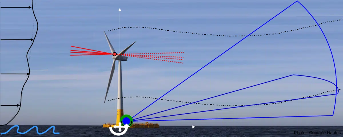
The WAKEFUL project aims to study the distant wake of a full-scale floating wind turbine in a real meteorological and oceanographic environment.
The project is part of a joint LiDAR experiment involving the University of Stuttgart (VAMOS project), IDEOL, and LHEEA (Centrale Nantes – CNRS) to characterize the power curve, near wake, and distant wake of a floating wind turbine installed at the SEM-REV offshore test site (LHEEA).
One of the project’s objectives is to measure the distant wake of the floating wind turbine, several hundred meters downstream of the turbine, in order to understand its interaction with the movements of the float and the instabilities of the atmospheric flow, and thus test the ability of wake models to predict the behavior of a floating wind turbine.
To carry out this experiment, specific methods will be developed to compensate for the movements of the float on which a LiDAR is installed in order to ensure accurate measurements. The development and implementation of a LiDAR stabilization system in a horizontal plane (platform and/or post-processing) is the subject of the first part of the project. The second part concerns the measurement and analysis of compensated LiDAR data on the floating wind turbine. The project will take advantage of the simultaneous presence of several LiDARs to analyze the correlation between the wind turbine wake (CN scanning LiDAR) and the incident flow (USTUTT nacelle LiDAR) in order to study the temporal variations of the distant wake and its meandering (unsteady wake).
The project also plans to use scanning LiDAR to establish atmospheric databases on the site.
Scientific breakthroughs and innovation
- Definition of measurement methodologies using LiDAR scanning on a floating platform
- Analysis of data from floating LiDAR scanning
- Assessment of the relevance of unsteady wake models for floating wind turbines
- Documenting atmospheric forcing in the Atlantic
Expected technical and economic impact
- Compensate for the lack of data on the wake of floating wind turbines
- Analyze the dynamics of the wake of floating wind turbines to prepare for floating wind farms
- Develop tools for modeling the unsteady wake of floating wind turbines
Publications and presentations produced
Presentations at international conferences without proceedings:
- B. Conan, Scanning LiDAR field observation of near-offshore wind resource and extremes in the Northeast Atlantic coastal region of France, WESC 2021, 25-28 May 2021, Hannover, Germany (submitted)
- Offshore wind resource, B. Conan, S. Aubrun, I. Calmet, T. Desert, P. Keravec, L. Paskin, Y. Perrignon, J-M. Rousset, Seanergy, 21-24 Septembre 2021, Nantes, Saint-Nazaire, France.
First LiDAR measurement campaign in Penn-Avel as part of the WAKEFUL project in October 2019
The scanning LiDAR, a wind measurement instrument recently acquired by LHEEA (summer 2019, funded by the Region, ERDF, and PIA), was installed on the terrace of SEM-REV’s seaside villa in Penn Avel Park on the Croisic site on October 28.